- Spider maps, spider maps, easier to use than regular bike maps.
- Spider maps can help make bike commute planning more intuitive and accessible.
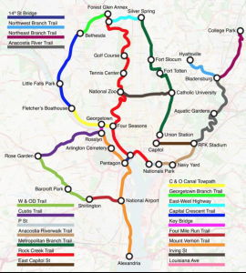
Map by Michael Graham.
Andrew Small at Bloomberg’s CityLab website had a great article last week called “What If Bike Paths Looked Like Subway Maps?” He featured the work of Michael Graham, who had the great idea of developing maps for bike infrastructure as if the lanes, trails, and paths constituted a connected transit system.
Graham taught himself how to create route diagrams, sometimes referred to as “spider maps,” that are intended to be intuitive for the people that use them. Think of the London Underground map or the Washington DC Metro Map.
According to Small, Graham says the idea for bicycle spider maps came to him in 2008 when his commute from southwest DC to McLean required numerous Metro and bus transfers. He realized he could switch to cycling when he found that bike paths covered almost the entire route to work. Graham said, “I am a cycling enthusiast, and it took me too long to discover the bike routes near my home and office. What about the average person?”
Graham wanted to take extremely detailed bike maps that the average person might find overwhelming and inaccessible and turn them into spider maps. He later attended a Transit Tech workshop in Arlington hosted by Mobility Lab, taught himself to use Adobe Illustrator, and then applied these concepts to bike maps for four cities: London, San Francisco, his hometown of Denver, and Washington, DC, which can be found on his website here.
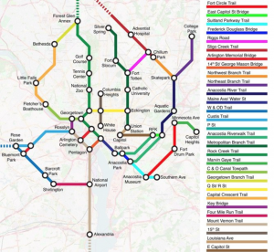
Revised Version of DC Metro Map. Map by Michael Graham.
FABB thinks this is a great idea to make biking more accessible and encourages local transportation officials to develop spider maps that include trails, side paths, and on-road bike infrastructure. Such visualizations also should help planners and advocates better identify network expansion needs and gaps within the network.