 Just in time for Bike Month, the Virginia Department of Transportation (VDOT) has launched something many of us have been waiting for—a new statewide Active Transportation Map Hub.
This user-friendly, mobile-ready tool brings together a wide range of biking and walking data into one place, making it easier than ever to explore routes, understand conditions, and see what’s planned across Virginia.
What You Can Explore
- The new map hub includes a rich set of layers that will be useful for riders, planners, and advocates alike:
- Bike Facilities – Explore more than 1,660 miles of shared use paths and multiuse trails, 1,025 lane miles of on-street bike lanes, and 500+ miles of bike routes and sharrows statewide.
- U.S. Bike Routes – View designated segments of U.S. Bicycle Routes 1, 76, and 176, including routes that pass through Northern Virginia.
- Featured Places to Bike – Discover 35 highlighted trails and facilities, including local favorites like the W&OD Trail and Mount Vernon Trail.
- Active Transportation Count Sites – See where Virginia is collecting data on bike and pedestrian activity—an important part of building the case for future investments.
- Funded Projects – Get a look at upcoming Six-Year Improvement Program projects that include biking and walking infrastructure.
- Corridor Planning Studies – Explore current and recent VDOT STARS and roadway reconfiguration studies with active transportation components.
- Crash Data (2017–2025) – View mapped locations of reported bicycle and pedestrian crashes—critical for understanding safety challenges.
- Pedestrian & Bicycle Safety Action Plan (PBSAP 5.0) – Identify the highest-risk roadway segments across Virginia based on crash exposure data.
Why This Matters
For Fairfax County riders and FABB members, this new tool is more than just a map—it’s a window into how decisions are made about biking and walking infrastructure. It can help you:
- Plan safer and more connected routes
- Understand where improvements are needed
- Track funded projects and planning efforts
- Support advocacy with real data
Good data leads to better decisions—and stronger advocacy.
More Features on the Way
VDOT is continuing to build out the platform, with additional layers coming soon:
- Statewide sidewalk inventory
- Statewide crosswalk inventory
- Bikes-on-train information
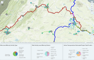
The hub also includes dashboards with key bike and pedestrian metrics across Virginia.
Where to Find It
You can access Virginia’s new statewide Active Transportation Map Hub here. It also can be found on VDOT’s Maps page under bicycling maps and on its Bicycle and Pedestrian Program page under related links
A Tool for Riders—and Advocates
At FABB, we’re excited to see this kind of statewide resource come online. Tools like this help make biking more transparent, more understandable, and ultimately more accessible.
Whether you’re planning your next ride or advocating for safer streets in your community, this map hub is well worth exploring.
Take a look—and see how Virginia is building a more bikeable future.