
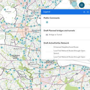
 Fairfax County has released the DRAFT Active Fairfax Transportation and Trail Network Plan map, a major update to the Bicycle Master Plan and the Countywide Trails Plan. This map outlines recommendations for bicycle and pedestrian infrastructure across the county. However, key areas like parks, towns, and cities, as well as special planning areas, are not depicted on the map.
The map’s legend, located in the top right corner, explains the facilities and reference information it displays, including road names, schools, hospitals, and land use categories. Infrastructure recommendations rely on Table 1, which provides guidance based on traffic volume, speed limits, travel lanes, and land use. Specific infrastructure details, such as “bike lanes” or “sidewalks,” are not directly shown; for park-related recommendations, users must refer to park-specific comprehensive plans.
At FABB, we’re closely reviewing the map with a focus on connectivity. Our goal is to identify gaps in the proposed network and suggest improvements for specific roadways. To do this effectively, we need your help.
We’re seeking volunteers to review the draft map, ideally by Supervisor District. Reviewers need to consider:
- Do the proposed facilities connect seamlessly?
- Are there barriers or gaps that remain unaddressed?
You can submit your feedback to us at [email protected], and we’ll include it in our collective comments to Fairfax County. Alternatively, you can share your thoughts directly by taking the Active Fairfax Transportation Plan survey.
The public comment period ends on December 20, so don’t wait! Download the map, take a closer look, and help ensure a better-connected, more accessible Fairfax County. Together, we can advocate for the infrastructure our community needs.


