by Richard Weisman
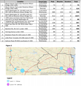
Example of VDOT NOVA District map and 24-hour bike count data.
During the COVID-19 pandemic, Northern Virginia appears to have seen a significant growth in bicycling. Unfortunately, only limited information is available about the number of bicycle trips taken in Fairfax County and most of the data pre-dates the pandemic. Unsurprisingly, an evaluation of data provided by VDOT and county resources shows that the largest numbers of bicycle counts were for locations along the W&OD, Custis, and Mount Vernon trails.
VDOT’s geographic-based map (http://www.virginiadot.org/travel/nova-mainBicycle.asp) provides static data for several dozen locations within Fairfax County and other parts of Northern Virginia. It includes daily bicycle counts conducted between 2011 and 2019 and gathered from various local agencies and VDOT sources. The VDOT’s Northern Virginia office relies on Arlington’s count dashboard for real-time data and historical data. These counts do not include Fairfax but cover Alexandria and a few other neighboring jurisdictions.
Time-series data provided by Bike Arlington (http://counters.bikearlington.com/) for Bon Air Park west shows a substantial increase in bicycle counts from pre-pandemic to during the pandemic. For example, comparing bicycle counts from June 2019 to June 2020 showed an increase of approximately 150% (from an average of 1,290/day to 1,950/day) at that location. Other locations reported by Bike Arlington did not show similar increases (for example, the connector to Crystal City) possibly due to the extensive teleworking during the pandemic.
The daily bicycle counts reported by VDOT for other locations within Fairfax County were relatively smaller than the counts for the W&OD trail. For example, counts at locations in the Tysons area were typically less than 50 per day – 20 on a weekday in May 2016 at Woolford Road south of Old Courthouse; 8 on a weekday in November 2016 at Dolley Madison Blvd between Anderson Road and Colshire Drive; and 32 on a weekday in November 2016 at Spring Hill Road north of Rt. 267. A few locations near Tysons showed higher counts such as 157 on a weekday in June 2016 north of Wolf Trap Road near the Dunn Loring fire station and 53 on a weekday in June 2016 at Leesburg Pike between I-495 and Magarity Road/Lisle Avenue. This data, of course, pre-dates improvements in bicycle facilities in the Tysons area, such as the opening of the Vesper Trail, additional bike lanes, and the arrival of Capital BikeShare, which creates a major gap in any understanding of current bicycle travel in Tysons.
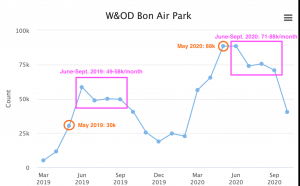
Data from Arlington’s Bike Count.
Despite the relatively sparse amount of data, a few conclusions are clear. First, it confirms the longstanding position of bicycle advocates that trails separated from motor vehicle travel (such as the W&OD trail) get significantly more use than unprotected bike lanes and sharrows (such as in Tysons). More important, the absence of adequate data to evaluate bicycling as a mode of transportation for accessing employment, education, and retail within Fairfax County hinders transportation planning. Finally, time-series data appear to be a useful tool to help county and regional planners better visualize the inclusion of bicycling into a regional transportation network.
Collecting additional data about bicycle counts in Fairfax County and throughout the Northern Virginia area should be a priority for county and regional planners. Collected data should illustrate bicycle counts on a regular basis over a multi-year period and be publicly-available. Counting locations should include those along major trails as well as other key transportation routes. The 2015 Fairfax County Bicycle Master Plan recommended a countywide bicycle counting program to include data collection and performance measurement to track plan implementation and benefits. This should occur throughout the county including underserved areas.