 The Virginia Department of Transportation (VDOT) has a Statewide Bicycle and Pedestrian Program that over the past three years has conducted bicycle and pedestrian specific counts at over sixty locations throughout the Old Dominion. Using both permanent and temporary counting equipment, the program has developed a map that shows the locations and the data collected as well as counts conducted by other entities.
As part of its effort to expand this program and include locally conducted counts to form a Statewide Counting Network, VDOT is inviting local governments and individuals to request a count by filling out this form. The Fairfax County Department of Transportation (FCDOT) is working with VDOT on developing a counting plan for the county. VDOT plans to move the counters around every few weeks to gather as much information as possible. FABB also is preparing its own suggestions and encourages others to provide their inputs.
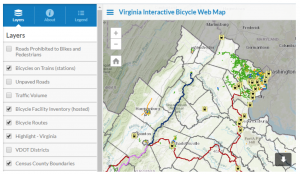
In addition, a new “Virginia Interactive Bicycle Web Map” is available from VDOT. This ArcGIS online map provides new information and combines data from other sources in one place. Available layers include bicycle facilities, train station information, U.S. Bicycle Routes, unpaved roads, roadways prohibited to bicyclists, and traffic volumes. VDOT is inviting local riders to review these maps for accuracy in their area and provide corrections and feedback here. Please help make this best and most informative map possible.