On June 5, 2019, the Fairfax County Department of Transportation held a public hearing on its Intersection Improvement Study at Spring Hill Road and Lewinsville Road. The study includes plans for bike and pedestrian facilities, which is good, but the hearing highlighted a couple of problems with how bike infrastructure is presented to and considered by residents.
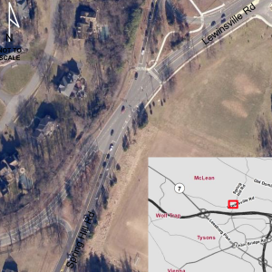
Squashed-X Intersection at Spring Hill Road and Lewinsville Road
The intersection under study is just north of the Tysons where the main Dulles Toll Road plaza causes untold numbers of motorists to cut through local neighbors to get to I-495 in what can only be a vain attempt to avoid congestion and save some money. The intersection’s squashed-x geometry is unusual and confusing, making it the site of an extraordinarily high number of head-on and other collisions, according to the FCDOT presenters [a description of the FCDOT plans and other problems for motorists and cyclists is included at the end of the blog].
As a biker who attended the meeting, I noticed that the inclusion of the notional on-road (and unprotected!) bike lanes only confused people about the plans and their actual operation if installed at this difficult intersection. While I’m always glad to see bike and pedestrian infrastructure included, their placement in the road at an extremely dangerous intersection should have been immediately obvious to the planners as untenable. Not surprisingly, there were a number of negative—but probably accurate—comments that adding bike lanes through the intersection would only multiple the confusion. Others used the opportunity to question the value of bike lanes because they never see anyone using them.
I was told that the notional bike lanes were based on the Bicycle Master Plan, which isn’t a problem in itself but should lead to a more careful presentation of the information. The Bicycle Master Plan, after all, is just a plan. It can and should be updated to accommodate the realities of worsening traffic congestion in many areas since its creation in 2014-2015. In fact, the plan is supposed to be reviewed and updated, and FABB continues to urge the county to budget money for this endeavor.
Also, FCDOT and VDOT are well aware that many people are disinclined to support bike lanes and don’t understand that bike lanes are being added in pieces in the most cost-effective way possible. If a study or plan includes bike infrastructure, the presenters need to say more to educate the attendees about the purpose and process for adding bike lanes. Also, it might help build support for this needed infrastructure if the graphics included options for on- and off-road lanes. At this meeting, it was clear that on-road bike lanes were a bad idea. Because the plans included sidewalks, it should have been an easy change to make space of a wide multi-use path to help people traverse the area, especially with a school and a county recreation center nearby. The potential impact on right-of-way, traffic calming measures, and other benefits might have increased public support for adding the best possible bike-pedestrian facilities. FCDOT (and VDOT) should include at least one slide in their presentation that explains the benefits of improved bicycling infrastructure, including the impact of getting people out of their cars on congestion.
Several other studies seeking to improve numerous troublesome intersections in and around Tysons, such as the Dolley Madison Corridor study, are ongoing. Hopefully, future presentation will provide more context about bicycle and pedestrian infrastructure to inform the public and build support for these needed changes.
*****************************
This is a long blog, but if you have time and are interested, here is some more information on the intersection:
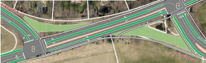
Offset-T
Of the two plans FCDOT is considering for improving the intersection, the offset-T is clearly superior in terms of safety for motorists, pedestrians and bikers. Attendees at the meeting, however, seemed put off by the need when traveling east and west to make two turns at two lights. The modified x-shaped intersection seems to provide only improvements at the margins. With attendees viewing the project in a motorist mindset, this approach seemed more popular. You can register your thoughts on the study here.
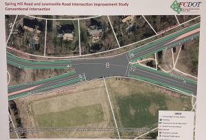 The existing intersection is not one a bicyclist should ride through during rush hour, although it is the only direct route from neighborhoods north of Tysons to get to “America’s Next Great City.” The current intersection’s large footprint makes it difficult to judge gaps for turning while drivers who slow down or stop as they try to figure out how to safely make a turn are occasionally rear-ended. Failure to yield is a serious problem, and there are no left-turn lanes on the eastbound, northbound, and southbound approaches. (The offset-t and conventional intersections will add turn lanes.)
Currently, there is only one west-bound bike lane on Lewinsville Road that runs up to the intersection where, as is so common, there are no good connections to anything other than inadequate sidewalks or narrow paved trails. The inadequate connections, heavy traffic, high speeds on Lewinsville Road’s wide lanes east of the intersection, and poor sight lines on Spring Hill Road’s narrow and curvey course undoubtedly discourage many riders. Even during non-rush hour periods, pedestrians and bicyclists trying to cross the intersection’s wide footprint find themselves at serious risk as frustrated motorists rush through the intersection as quickly as they can.
If Tysons continues to develop as planned with intentionally limited parking, we are not far away from bicycle and pedestrian traffic increasing in both directions along Spring Hill Road. BikeShare in Tysons also will be increasing the number of riders in the area, and if a station is placed at the Spring Hill Rec Center, better biking and walking infrastructure will be needed to connect the areas on either side of the Toll Road. There is a lot going on in this small area and, hopefully, FCDOT planners will continue to look at fixing intersections with an eye toward improving and connecting the bike infrastructure.